How we move forward ???
Notes and Pictures on Land Areas and approximate sizes
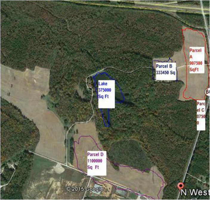
Size of Cleared Land on N West Ave and Rt 460 Ramp
550 ft is on Rt 460 and Ramp Frontage
A. Main N West Avenue
1650 ft on N West Ave Length 550 ft Width
907500 Sq Ft
21 Acres
Size of Cleared Land on N West Ave and Rt 460 Ramp
550 ft is on Rt 460 and Ramp Frontage
A. Main N West Avenue
1650 ft on N West Ave Length 550 ft Width
907500 Sq Ft
21 Acres
|
B. Secondary Land behind Main N West
513 Length 650 ft Width 333450 Sq Ft 7.5 Acres |
C. Tertiary Triangle Parcel
500 ft length 175 ft Width 87000 Sq Ft 2 Acres |
|
D. Babs Lane Parcel
2000 Ft Length 550 Ft Width 1100000 Sq Ft 25.5 Acres |
Existing Lake
375000 Sq ft 8.5 Acres |
This tract is zoned "B-G," Business-General (approximately 45 acres) along State Road 606, and the balance of the tract is zoned "R-1" Residential, with the exception of 14.78 acres zoned A-1 that provides additional access to State Road 625. The topography is flat to rolling, and there are approximately 140 acres of open fields currently in production using "no till" farming techniques for alternating crops of wheat and soy beans. The majority of the tract is designated "Prime Farm Land" by USDA NRCS, and additional acres can be converted to cropland. A copy of the USDA soils map is available upon request. An agricultural lease on the property is a cash-flow option while development opportunities mature, and the current farm lessee is a Virginia Environmental Stewardship and Bayer Crop Science National Sustainability award winner. The balance of the tract, 335 acres, includes the 7-acre pond and 6-acre cabin site and is currently in timberland.
The tract also features 5,900 feet of frontage on HWY 460, plus 3,900 feet of frontage on State Road 606 and 3,300 feet of frontage on BABS Road. A short list of B-G zoning uses includes hotels, gas stations, restaurants, and many other uses. R-1 zoning provides for single family dwellings with a density of 1 to 3 units per acre. City water and sewer are available at the southern end of the tract, and additional conversion to B-G zoning is possible. Contact Broker for a complete description of B-G and R-1 zoning.
The tract is located at the intersection of US HWY 460 and State Road 606 on the north side of Blackstone, VA. It is further identified as Nottoway Co. Tax Parcel 42-A-86, and the legal description is found in Nottoway County Deed Book 276 at page 474. A 1997 survey of the tract is available.
Major Sectors of the Development
|
|
WATCH THE VIDEO
|
|
Cultural and Education Components
|
Sports Recreation Indoors
|
Traffic Studies Survey
http://www.virginiadot.org/info/2013_traffic_data.asp
Page 643. Blackstone Area
http://www.virginiadot.org/info/2013_traffic_data.asp
Page 643. Blackstone Area
